The Frans Josef Glacier
Courtesy of Wikipedia
The first European description of one of the west coast glaciers (believed to be Franz Josef) was made in the log of the ship Mary Louisa in 1859. The glacier was later named after Emperor Franz Joseph I of Austria by the German explorer, Julius von Haast in 1865. The Māori name for the glacier is Kā Roimata o Hine Hukatere ('The tears of Hine Hukatere'), arising from a local legend: Hine Hukatere loved climbing in the mountains and persuaded her lover, Wawe, to climb with her. Wawe was a less experienced climber than Hine Hukatere but loved to accompany her until an avalanche swept Wawe from the peaks to his death. Hine Hukatere was broken-hearted and her many, many tears flowed down the mountain and froze to form the glacier. Following the passage of the Ngai Tahu Claims Settlement Act 1998, the name of the glacier was officially altered to Franz Josef Glacier / Kā Roimata o Hine Hukatere.
Advance and retreat
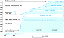
Franz Josef Glacier is currently 12 km (7.5 mi) long and terminates 19 km (12 mi) from the Tasman Sea. Fed by a 20-square-kilometre (7.7 sq mi) large snowfield[7] at high altitude, it exhibits a cyclic pattern of advance and retreat, driven by differences between the volume of meltwater at the foot of the glacier and volume of snowfall feeding the névé. Franz Josef Glacier had periods of advances from 1946 to 1951 (340 m), 1965–1967 (400 m), 1983–1999 (1420 m) and 2004–2008 (280 m).[8] The glacier advanced rapidly during the Little Ice Age, reaching a maximum in the early eighteenth century. Having retreated several kilometres between the 1940s and 1980s, the glacier entered an advancing phase in 1984 and at times has advanced at the phenomenal (by glacial standards) rate of 70 cm a day. The flow rate is about 10 times that of typical glaciers. Over the longer term, the glacier has retreated since the last ice age, and it is believed that it extended into the sea some 10,000 to 15,000 years ago.
This cyclic behaviour is well illustrated by a postage stamp issued in 1946, depicting the view from St James Anglican Church. The church was built in 1931, with a panoramic altar window to take advantage of its location. By 1954, the glacier had disappeared from view from the church, but it reappeared in 1997. This is due to the highly variable conditions on the snowfield, which take around 5–6 years before they result in changes in the terminus location.
The glacier was still advancing until 2008, but since then it has entered a very rapid phase of retreat. As is the case for most other New Zealand glaciers which are mainly found on the eastern side of the southern alps, the shrinking process is attributed to global warming.
There have been some incidents of jökulhlaups (outbreak floods from water-filled ice tunnels) at the glacier, with one destroying a bridge on the access route in 1989.
Based on past variations, scientists expect that Franz Josef Glacier will retreat 5 km and lose 38% of its mass by 2100 in a mid-range scenario of warming.


Comments
Post a Comment